localthings as an alternative to Google My Maps
Google My Maps is a capable free map builder with layers, marker styling, photos, spreadsheet imports, lines, shapes, public links and embeds. localthings is the narrower option when the map must work as a branded public directory with structured location cards and its own product identity.
- Choose Google My Maps for a free map with up to ten layers, broad file imports, collaborative editing, lines, shapes and a free public embed.
- Viewers can show and hide layers, search the map and open places with descriptions or photos; it is not a pin-only tool.
- Choose localthings for a branded map and list with category filters, structured location cards, product support and, on Premium, analytics and your own domain.
- localthings publishes a permanent link on Free and generates embed code from Basic. Moving from My Maps starts with a CSV export.
localthings vs. Google My Maps
A factual comparison on the points that matter to most people.
| Feature | localthings | Google My Maps |
|---|---|---|
| Public link and website embed | Link on Free, embed from Basic | Free |
| No code required | ||
| Layers or categories viewers can toggle | Category filters | Up to 10 layers |
| Colours, icons, descriptions and photos | ||
| Map plus structured directory list | Layer and item panel | |
| Lines, directions and shapes | Pins and closed areas | |
| Spreadsheet and geodata import | CSV, JSON or pasted rows | CSV, XLSX, Sheets, KML, KMZ and GPX |
| Own domain and no third-party product chrome | Domain on Premium, branding removal on Custom | |
| Visitor analytics on your map | On Premium |
When Google My Maps is the right call
Choose Google My Maps when free publishing matters most, Google Drive collaboration fits your workflow, or you need lines, directions, shapes and broad imports such as KML, GPX or XLSX. It can publish publicly and embed on a website without a paid map plan.
When localthings fits better
Choose localthings when the public map is part of your product or organisation: a consistent map and list, category filters, structured fields such as opening hours and route buttons, your branding, support and an optional custom domain without Google product chrome.
A public directory with its own identity
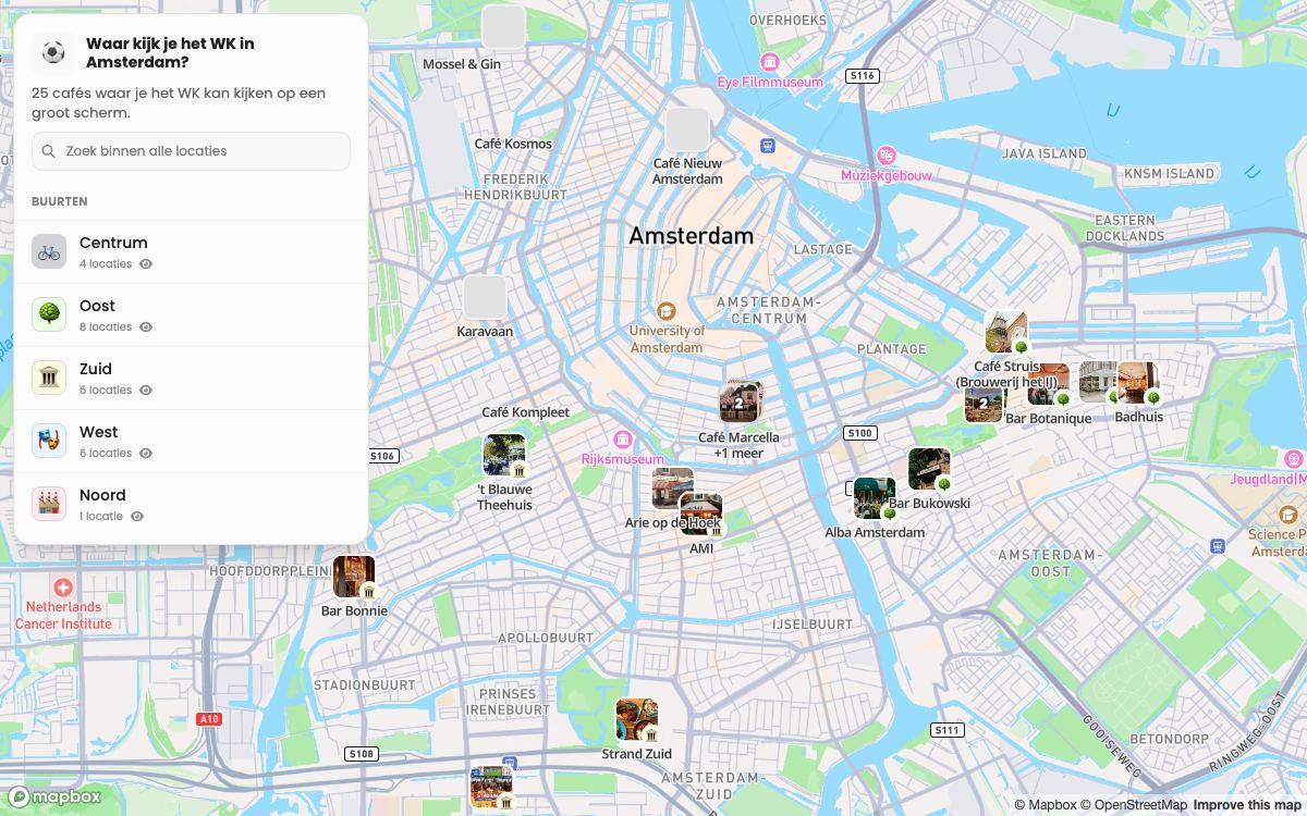
This published localthings map gives visitors 25 Amsterdam cafés in a branded map and list. It demonstrates the structured public experience described here, not an inability of My Maps to show photos or layers.
- 25 cafés, each with its own photo and description.
- Grouped by district, which is what the visitor filters on.
- Works on a phone without an app or a Google account.
- One link, which you update without republishing.
Frequently asked questions
Can I move my Google My Maps map to localthings?
Yes. Export your locations from Google My Maps as CSV or KML with the addresses, then import that file. After the import you set up categories, colours and your own branding.
Is localthings free like Google My Maps?
Free includes one map with up to 100 visible locations and a permanent link. Embedding starts on Basic; a custom domain and analytics are Premium; branding removal is Custom.
Can I put the map on my own website?
Yes. Sharing through a permanent link is available on Free; an embed snippet starts on Basic. On Premium the map can live on your own subdomain. Removing localthings branding is Custom.
How do I make a map with multiple locations in my own style?
Google My Maps can style locations by colour and icon and lets viewers show or hide layers. localthings adds a more opinionated branded directory with category filters, a list view, structured location cards and, on Premium, a custom domain without third-party product chrome.